In three Vietnamese cities homing over 9 million people, how can we begin to identify the highest risk school zones and the children who use them daily to tackle the leading killer of youth – road traffic crashes. The answer? Big Data.
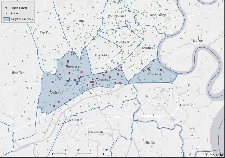
A Big Data Screening Methodology developed as part of the AI&Me Project has enabled desktop analysis of big data for Ho Chi Minh City, Pleiku and Yen Bai. The analysis identified the 106 highest risk schools for further road safety investigation and prioritised investment from a total of 1,063 schools analysed.
Informed by the findings, the project will star rate the safety of the schools using the Star Rating for Schools application, pilot a new YEA youth engagement app with 1,800 students mapping where they feel safe and unsafe on their walk to school, and work with local government decision-makers to implement infrastructure improvements at 18 priority schools.
Big data sources are becoming more readily available and provide insights on a wide range of urban environment elements that can represent a road safety risk. Working with big data to identify high-risk locations is an efficient and effective way to scale up city, region or country-wide evaluations.
The Methodology used big data sources, particularly telematics and satellite data, to collect road, infrastructure and sociodemographic attributes and flag risky schools where the combination of the environmental elements might represent a risk for students.
The attributes were ranked by their risk in four levels, an approach which helped save cost and analysis effort. Level one included freely available information and, as the levels progressed and scope area reduced, more complex, costly and detailed data could be collected and analysed in a very focussed way.
“This approach allowed us to scope how the analysis was done and draw upon available big data to analyse and compare 1,063 schools. It also gave us the ability to hone in on and assess a range of risk parameters at scale and at the individual schools level across Vietnam,” said Peter Jamieson, Managing Director of data analytics company, Anditi.


Levels progression and changes in the scope of the analysis – Images source: Anditi and iRAP
AI&Me Project Manager Shanna Lucchesi from the International Road Assessment Programme (iRAP) said that, to the best of our knowledge, this is the first time a big data methodology has been developed and piloted to assess road infrastructure risk around schools.
“The three cities are very different in size and complexity, proving how flexible the Methodology is to adapt to different contexts,” said Ms Lucchesi.
“We’re thrilled to be piloting the AI&Me programme in Vietnam, where we’ll be able to use big data to change the way we think about, approach, and solve the road crisis,” said Trang Truong, the AI&Me Project Manager for AIP Foundation.
“The local government agencies also gathered information on pedestrian fatalities and the number of students. The methodology was shared with our local government partners and schools in Vietnam. The post-training survey showed that 86% of participants found the Big Data Screening methodology presented in the training useful or very useful for government stakeholders to identify high-risk communities and locations more easily.
“Not only has the Methodology revealed exciting insights for application in Vietnam, it’s designed to be scalable, transferable, affordable and easy to apply anywhere in conjunction with the iRAP Star Rating for Schools (SR4S) app to refine a priority list of sites for detailed assessments,“ Ms Lucchesi said.
“Together with SR4S, the method will help decision-makers make effective and evidence-based choices on where to focus road safety efforts, linked to the highest impact and most cost-effective interventions to save children’s lives,” she said.
Road crashes disproportionally affect young people, as the leading killer of people aged 5-29 years worldwide.
The combination of unsafe road conditions near schools, the special vulnerability of children, and the elevated risk tolerance of young drivers, expose youth to the daily risk of road injury and death.
An estimated 500 children will die on the global roads every day, and more than 10,000 will suffer life-changing injuries, posing enormous economic and social implications for future generations.
Despite these unacceptable levels of youth trauma, the true scale of the problem is often hidden from community consciousness, while also feeling too large to tackle.
Ms Lucchesi said it can be overwhelming for governments to know where to begin prioritizing safety and for whom, and decide where to focus investment in road modifications or enforcement.
“The Ai&Me Project is exciting not just in its innovative big data approach but also the comprehensive involvement of all people impacted and able to help – from the students, to school administrators, local government representatives responsible and empowered to make investment decisions, and global road safety and data experts with the latest know-how. They are all coming together to protect those most vulnerable at school roadsides and support government decision-making.
“We are excited about the Big Data Methodology, the insights it has revealed and very targeted road safety improvements it will make possible in the three cities. We’re also excited by its global potential to make schools journeys safer in the most cost effective way far beyond the borders of Vietnam,” Ms Lucchesi said.
The Methodology has been developed as part of the AI&Me: Empower Youth for Safer Roads Project founded by Fondation Botnar and FIA Foundation, led by AIP Foundation, and supported by iRAP and ANDITI.
For more information on the Methodology, download the AI&Me Big Data Methodology Report here.
It will also be presented at the International Walk21 Conference to be held next week from 19-23 September in Dublin.
Header image source: Vương Bùi on Pixabay

